GETTING TO CALABRIA

GETTING TO CALABRIA
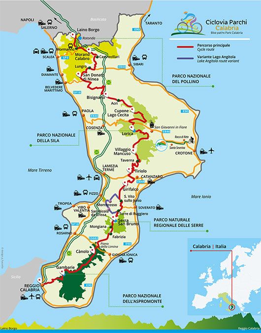
Calabrian park’s cycle network can be travelled in both directions, starting from Laino Borgo or Reggio Calabria.
By train: if you want to get here by train, we inform you that since October 2020 passengers have been able to travel on the Rome-Reggio Calabria Intercity trains with an assembled bike on board with them. The train runs along the Tyrrhenian coast and stops in the region's main towns, which are on average 40 km from the Ciclovia. From the Scalea railway station, the first stop on Calabrian territory coming from the north, the Ciclovia can be reached by bicycle at Mormanno (on stage 1 Laino Borgo-Morano Calabro), either along the SP3 towards Papasidero (45 km), or using the route to Orsomarso (36.3 km), which is shorter but with very challenging climbs. Otherwise, you can use the TNC Trasporti Nord Calabria bus to reach Mormanno (line 365, departure from Scalea 5:30 - 9:30 - 17:30, departure from Mormanno 5:55 - 14:50, Monday to Saturday; info tel. +39 0981 63450 e-mail:
From Scalea station to Laino Borgo can be reached using the following chauffeur-driven transport services: Cersosimo NCC Glamour, which can transport up to 10 people with bikes in tow [booking required, tel. +39 347 0552700]; Ciclo Park Morano can transport 9 people and 8 bikes [booking required, tel. +39 391 3552775 - e-mail:
You can also reach the Ciclovia using the FS Jonica line, Taranto-Reggio Calabria, with a stop at the Sibari station: from here, you can cycle to Castrovillari (which is at the beginning of stage II) using the SP263 (31.3 km +447m - 78m); or, you can take the train to Cosenza, and get off at the Ferramonti-Tarsia and Torano Lattarico stations (stage III), are respectively 7.6 km and 11.4 km from Tarsia and Bisignano.
By air: if you want to travel by air, you can use the airports of Lamezia Terme (domestic and international flights), Reggio Calabria (domestic flights from Milan Linate and Rome Fiumicino with ITA Airways) and Crotone (domestic flights from Bologna and Bergamo with Ryanair). At Lamezia Terme airport you’ll find all the areas for packing and unpacking your bicycle and taxi services to reach the cycle route with bikes in tow and Taxi services to reach the cycle route with bikes in tow
By car you can reach various towns crossed by the cycle network or arrive very close to them, both one the Tyrrhenian and the Ionian coasts. From the west, take the Salerno-Reggio Calabria (E45), which runs along the Tyrrhenian coast heading inland in the territories of the Pollino National Park and the Serre Regional Park; from the east, take the state road SS106 Taranto-Reggio Calabria (E90), which travels along the Ionian coast and connects all the panoramic roads that cross Calabria from coast to coast.
By bus: one more way to get to the cycle network and take your bike with you is Flixbus, which connects the main Italian cities with the towns crossed by the cycle network, including Mormanno, Firmo, Tarsia, Bisignano, Acri, in the north, and Reggio Calabria, in the south.
Very convenient for its proximity to Laino Borgo is the Flixbus stop in Galdo di Lauria, Basilicata. From here it is easy to reach Laino Borgo by bicycle, travelling 20 km downhill (+160 m | - 620 m), mostly on the scenic cycle path built on the former Ferrovia Calabro-Lucana railway line.
In particular, for those arriving by plane or train, Flixbus offers daily connections from Naples Capodichino airport and Salerno railway station.
Travelling within Calabria
The parks cycle network is made up of the all the cycling roads, paths and routes that wind along the main ridge of the Calabrian Apennines. The route, which crosses the Aspromonte, Sila and Pollino National Parks and the Serre Regional Park, crosses or borders some of the main arterial roads of the region: the Mediterranean highway [A2], the European roads E844 (Firmo-Sibari), E846 (Paola-Crotone) and E848 (Lamezia Terme-Catanzaro). The route connects the 4 regional parks mainly through provincial roads, with a traffic rate of less than 50 vehicles/hour. Within the parks, the cycle network is linked to paths or tracks used by hikers to enjoy the natural landscape of the protected areas. It is 545 km long, of which about 323 km are outside the parks. The altitude goes from a minimum of 19 m asl and a maximum of 1565 m asl.


